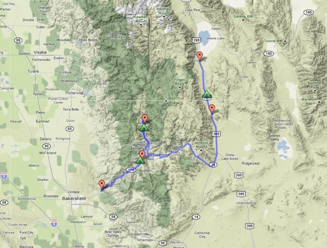
The Plan
september 15 - 18, 2011

Approximate
Itinerary. Subject to change significantly in topic, scope, and
authorship. Detailed camp and stop locations will be provided in the
guidebook and road log.
---
Thursday PM, September 15th - Kern Valley Campsite
Gathering of the Friends - Keyesville Recreation Area
---
Friday AM, September 16th - Kern River Gorge
Welcome, opening comments, and tectonic overview (Kelson, Lutz, Unruh - WLA)
Pleistocene record of the Kern River lacustrine delta (Negrini - CSU Bakersfield)
Tectonic geomorphology of the southern Sierra Nevada (Stein and Knott - CSU Fullerton)
Friday AM-PM, September 16th - Needles Overlook
Pleistocene deformation of the Flatiron and upper Kern Canyon (Kelson - WLA)
Late Quaternary slip rate on the northern Kern Canyon fault at Soda Spring (Amos - UCB)
Friday PM, September 16th - Corral Creek trench site, Upper Kern Canyon
Record of surface-rupturing earthquakes at Corral Creek (Streig - U Oregon, Brossy - WLA)
Soil development and age estimates of Kern Canyon landforms (Sowers - WLA)
Archaeological record of Kern Canyon (Rehor - URS)
Rupture history of the southern Kern Canyon fault (Kelson - WLA)
Friday PM, September 16th - Kern River Campsite
---
Saturday AM, September 17th - Lake Isabella Auxiliary Dam
Rupture
history of the Lake Isabella section of the Kern Canyon fault, Fault
displacement hazard analysis for the Auxiliary Dam (Lutz, WLA)
Rupture Scenarios, Moment Balancing, andCharacterizing Earthquake Hazards (Kelson - WLA)
Status and scope of the Isabella Dam project (Rose - USACE, Simpson - URS)
Saturday AM-PM, September 17th - Chimney Peak Road
Cenozoic Kern Plateau deformation along the Pinyon Peak fault system
Saturday PM, September 17th - Little Lake and Fossil Falls
Pleistocene geomorphology and active tectonics of Little Lake area (Amos - UCB, Jayko - USGS, Rood - LLNL)
Saturday PM, September 17th - Rose Valley
Climate and paleoenvironmental implications of black mat deposition in Rose Valley (Jayko - USGS)
Saturday PM, September 17th - Camp in Rose Valley
*Business Time*
---
Sunday AM, September 18th - Southern Owens Lake
The southern Owens Valley fault zone (Jayko - USGS)
Liquefaction associated with the Olancha earthquake sequence (Hancock - Inyo Co., Jayko - USGS)
Refining the southern extent of the 1872 Owens Valley rupture: Paleoseismology at Sage Flat (Amos - UCB, Lutz - WLA)
Sunday PM, September 18th - Oak Creek (optional stop)
The Oak Creek debris flow of 2008 (Wagner, CGS)