2024 Pacific Cell Friends of the Pleistocene Field Conference
Nevada
When: 13-15 September 2024
Trip Leaders: Rick Koehler, Mark Stirling, Paula Figueiredo, Marith Reheis
Final Announcement
I just noticed that printing the pdf results in the page numbers disappearing. I guess below the margin or some footer nonsense. In the words of Yoda “a copyright typeset editor I am not”. Sorry about that. So if you print it you will need to number the pages yourself (old school with a pen). Start with Table of Contents as page 2 and number sequentially from there.
The images in the guidebook are more clear on a tablet, but the printed version will get you what you need. The idea was to make the guidebook with a small enough file size to email (so some image quality suffered).
Good news. 36CL depth profile ages are hot off the press just in time for FOP! Should spawn some great discussion on geomorphology and soils vs. geochronolology and give some great perspectives on fault slip rates.
Below I paste the directions to the camp site (from the guidebook) and attach a kmz of the site if you want to plug it into your phone.
There is cell phone coverage close to camp (maybe even in camp) so feel free to reach out if you get lost (415) 412-7068.
Finally, be sure to bring some kind of cup for refreshments.
Looking forward to seeing you all. The weather is looking favorable, 80’s during the day and 40’s at night.
Cheers,
Rich et al.
Rich D Koehler
Associate Professor
Nevada Bureau of Mines and Geology
University of Nevada, Reno
To FOP central camp – road log and map
Exit 231 off Highway 80 at Battle Mountain (40.635059, -116.946698). This is the last place to fill up on gas and supplies. The Maverick gas station is just over the overpass on the north side of the highway.
Zero odometer. Head south on State Route 305.
11.1 miles. (40.510673, -117.074423) Turn right Copper Canyon/Buffalo Valley Road towards Nevada Gold Mines Phoenix Mine. Watch for mine truck traffic.
12.1 miles. Road turns to dirt.
15.4 miles. Take fork to left. (40.479348, -117.144041) Sign says “Buffalo Valley road to Willow Creek, Buffalo Valley, Jersey Valley, Dixie Valley, and Highway 50”.
27.5 miles. (40.365610, -117.299502) Turn right towards FOP central camp. In a few hundred feet stay to left at split. Continue down road for about 1.5 miles to camp.
Map to FOP central Camp – follow the yellow brick road.
Campsite Google Earth kmz file.

Announcement #3
Please remember that the camping is remote (not a campground) so bring all the supplies you need to stay happy. The camping is along a road that dead ends at the playa. The surface is relatively flat and suitable for tents. There are plenty of spaces to pull off the road between clumps of sage brush to set up camp. The site can be accessed without 4 wheel drive. However, some of the stops during the field days require driving up alluvial fans on roads that are rough. Thus, carpooling is recommended (find someone with a more suitable vehicle and jump in with them for the day). Alternatively, you can leave your small car on the main road and ride up to the stops with others.
We will leave for the field on Friday morning 9/13 at around 9 AM. It is recommended that you show up the night before (Thursday 9/12). I will be at the site by late afternoon on Thursday.
Feel free to email me with any questions but the guidebook road log and map will get you here.
Cheers and see you next week.
Rich, Mark, Marith, Tabor, and Quentin.
Rich D. Koehler
Associate Professor
Nevada Bureau of Mines and Geology
University of Nevada, Reno
rkoehler @ unr.edu
(775) 682-8763
Guidebook
Here is a link to the guidebook.
Announcement #2
Here is an update on this year’s Pacific Cell FOP September 13-15, 2024.
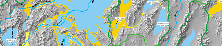
Planning is progressing and next week we will be running through the route to find the most suitable camping location. We hope to stay at the same site all three nights to minimize moving logistics. The map below shows the general route of the trip, but there will be some modifications after the reconnaissance trip.

Basically, we will travel between Highway 80 near Battle Mountain and through Reese River, Buffalo, and Jersey valleys, as well as across the Tobin Range to Pleasant Valley. As described in the last email, the scientific content will focus on active tectonics (trenches, slip rates, and event chronologies), alluvial fan evolution (recent dating, soils, geomorphology), and pluvial lakes (possible latest Pleistocene connections of pluvial Lake Buffalo to Lake Lahontan as well as possible previous higher lake levels). There will also be a bit of discussion on geothermal research in the region.
We have secured $565 of surplus funds from last year’s trip thanks to William Buckley and Tom Rockwell. It is our intention to use these funds to support registration fees for students on a first sign up first served basis.
A nominal fee for the trip of $30 for students and $35 for professionals will help offset costs for T-shirts, refreshments, porta johns, etc. The easiest way to pay is to Venmo me directly (Rich Koehler, venmo handle @Rich-Koehler-4, to verify the last 4 digits of my phone number are 7068). You can also just go old school and bring cash to the trip. The link below is a google sheet to sign up for the trip where you can list your name and T-shirt size. Please feel free to email the link to anyone you think might be interested (who may not be on the FOP listserve).
https://docs.google.com/document/d/1-oPbk-3paWxoGjVOhYH265cL2J092hxbKtmLZvkTiXo/edit?usp=sharing
Thanks friends………..more to come soon.
Your 2024 organizing crew
Rich, Mark, Paula, Marith, and Tabor
Announcement #1
Hello FOPer’s.
This years’ Pacific Cell Friends of the Pleistocene field trip will span 2 ½ days between September 13-15, 2024 in the general location of the Tobin Range, south of Battle Mountain, central Nevada. The trip will focus on recent and ongoing research on active tectonics, alluvial fan geomorphology, soils, and geochronology, the pre-history of pluvial lakes, and assessments of geothermal energy potential.
We will visit:
- sites along the Pleasant Valley fault zone including the 1915 Mw7.2 earthquake rupture, and discuss late Pleistocene and Holocene surface rupture events and long-term slip-rates supported by geochronology data from recent trenching (luminescence) and alluvial fans analysis (terrestrial cosmogenic nuclides)
- sites along the newly-mapped Buffalo Valley fault zone to examine fault scarps, soil development in alluvial fans, geochronologic results (36Cl depth profiles) that contribute towards slip rate estimates, and broader-scale tectonic geomorphology
- a site at the Jersey Valley/Buffalo Valley structural accommodation zone to discuss recent mapping, structural analyses, and geophysical studies related to the assessment of blind geothermal energy systems
- several highstand shoreline sites of pluvial lakes Lahontan and Buffalo, and discuss their possible hydrologic connectivity via the Reese River
The trip will involve remote camping as there are no formal campgrounds in the area. 4X4 vehicles are recommended. You should bring all the food and water you need. Some supplies (and gas) can be found in Battle Mountain, about an hour away. A small charge to cover beer, T-shirts, and porta pottys will be necessary, but it will be reasonable. We anticipate lively scientific debate in classic FOP style, and hope you can join us.
More details to come later.
Friendly yours,
Rich Koehler – University of Nevada, Reno
Mark Stirling – University of Otago, New Zealand
Paula Figueiredo – North Carolina State University
Marith Reheis – US Geological Survey, emeritus
Main Pages
Sign up for the email list for email notifications.